
Between the 19th and early 20th centuries, significant developments affected Ottoman Palestine. The Napoleon campaign (1799), the Egyptian occupation of Palestine (1831), the Tanzimat reforms, the end of the Crimean war (1856), the opening of the Suez Canal (1869), and Britain’s entry into Egypt (1882), all fostered international interest in the region. Additionally, substantial demographic changes occurred with the arrival of the 1st and 2nd waves of Jewish immigration. Notable changes occurred also in the large settlements such as the expansion outside the Old City of Jerusalem and Haifa as well as increased population and infrastructure establishments. These changes were documented in numerus textual sources but also in visual sources such as maps, drawings and photographs. Although textual sources are being widely used, visual sources are occasionally omitted. The latest technological developments enable an accurate interpretation and examination of these sources. In previous studies, I have used HGIS (Historical GIS) for historical map analysis and past cityscape reconstruction of Tiberias prior to and after the 1837 earthquake. In the proposed study, the recreation of historical scenes will be implemented by incorporating also machine learning capabilities. It is suggested to virtualize chronological cityscape key phases of Jerusalem and Haifa and accordingly examine the urban development, asses the residing population and identify changes in the human activity. The importance of the study is threefold: (1) the establishment of geospatial semi-automatic framework integrating traditional methodologies and technological innovations such as HGIS and machine learning for cityscape reconstructions; (2) adding new theoretical information about late Ottoman Jerusalem and Haifa by using visual sources that were insufficiently exploited so far; and (3) adding innovative methodologies and tools for interpreting and analyzing historical visual sources.
Resulted Papers (for pdf files go to publications page):
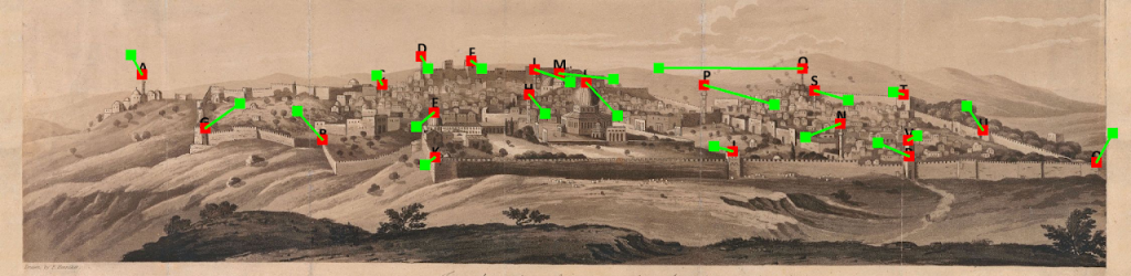
David, L., Zohar, M. and Shimshoni, I., (2023). Geo-referencing Entities Extracted from Old Drawings/Photos Using Computer Vision, Deep Learning and GIScience. ISPRS International Journal of Geo-Information, 12, 500. DOI: https://doi.org/10.3390/ijgi12120500
Zohar, M. (2022) A land without (a) people? The GIScience approach to estimating the mid-19th-century population of Ottoman Palestine. Applied Geography 141. DOI: https://doi.org/10.1016/j.apgeog.2022.102672 (map story)
Zohar M., Shimshoni I. (2021). GIScience integrated with computer vision for the examination of old engravings and drawings. International Journal of Geographical Information Science. DOI: https://doi.org10.1080/13658816.2021.1874957
Zohar, M., Shimshoni, I., & Khateb, F. (2020). GIScience Integrated with Computer Vision for the Interpretation and Analysis of Old Paintings. In Proceedings of the 6th International Conference on Geographical Information Systems Theory, Applications and Management – Volume 1 (233-239): GISTAM, Prague, Czech Republic. DOI: https://doi.org/10.5220/0009464902330239
Links:
A land without people? population estimation of Late Ottoman Palestine using GIScience approach (link)
Github [Zohar M., Shimshoni I. (2021)]: https://github.com/zoharmot2/GIScience-CV-old-drawings
Zenodo [Zohar M., Shimshoni I. (2021)]: https://zenodo.org/record/7003906#.Yv0fmhxByUk
The research was conducted with Prof. Ilan Shimshini, department of Information Systems, University of Haifa.
The research is funded by the Israeli Science Foundation