
Earthquakes were always meaningful to mankind as one of the most destructive natural hazards. The seismotectonic unit associated with much of the destructive earthquakes in the Levant is the Dead Sea Transform (DST) system. Thus, there is an ongoing effort to investigate the DST. Nevertheless, the research is limited to quantitative data which is available only for the last century, since the deployment of the first seismograph. Unfortunately, this period is too short in comparison with the slow tectonic processes and seismogenic cycles around and along the plate tectonic borders, including the DST. Thus, in order to inspect longer periods of seismic activity, other qualitative sources such as historical accounts, archaeoseismic remains and paleoseismic evidence must be used. Since the majority of these sources cannot indicate accurately of the size and origin of the earthquakes, the damage descriptions become the most effective information for the characterization of the triggering earthquakes.
The target of the proposed study is to examine the cumulative damage associated with the DST activity during the last 3,500 years and characterize potential temporal and spatial patterns. It is proposed to construct a consistent database of the damage caused by the historical earthquakes, adapt the EMS-98 intensity scale to the typical construction in historical times and accordingly assign intensity values. Once intensities are assigned, it will enable us to examine the spatial and temporal patterns of the earthquakes as well as the damage they caused and characterize the historical seismic activity. Previous studies showed that northern Israel was hit by many earthquakes that were originated from sources in the north, outside of Israel. The results of our work are expected to clarify and even quantify this type of events. It is also suggested to examine the cumulative damage in well-populated ancient cities of the Levant, and evaluate accordingly the potential hazard that threatens them. It is also anticipated that the study will allow to characterize the historical seismology associated with the activity of the DST as a complete seismotectonic unit as well as to assist planners and decision makers in understanding the shape of future earthquakes to come. The results of the study, GIS formatted, will be open to the public, thus increasing the awareness of seismic hazards in Israel.
Resulted Papers (for pdf files go to publications page):
Zohar, M., Salamon, A., Rapaport, C., (2023). How Expert Is the Crowd? Insights into Crowd Opinions on the Severity of Earthquake Damage. Data 2023, 8 (6), 108. DOI: https://doi.org/10.3390/data8060108
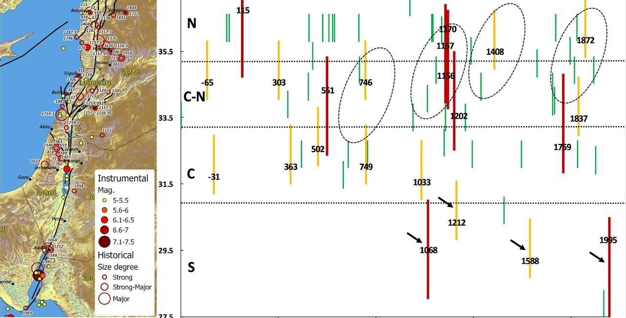
Zohar M. (2020). Temporal and spatial patterns of seismic activity associated with the Dead Sea Transform (DST) during the past 3000 yr. Seismological Research Letters. DOI: https://doi.org/10.1785/0220190124.
The research was conducted with Prof. Amos Salamon, the Geological Survey of Israel.
The research is funded by the Ministry of Energy