GIScience, GIS, and Geoinformatics: understanding the differences
The terms Geographic Information Science (GIScience), Geographic Information Systems (GIS), and Geoinformatics are frequently used interchangeably, often leading to confusion among researchers, professionals, and students in the field of spatial sciences. However, these terms refer to distinct concepts, each with its own scope, purpose, and application. This discussion aims to clarify the differences and relationships between them.
The term GIScience was first introduced by Michael Goodchild in his seminal 1992 paper, where he defined it as an independent scientific discipline that examines the theoretical foundations, principles, and methodologies underlying the acquisition, management, analysis, and visualization of spatial data. GIScience extends beyond the mere use of GIS software and tools—it encompasses fundamental research on spatial analysis, geostatistics, spatial cognition, spatial data infrastructures, and the social and ethical implications of geographic data. It addresses questions such as how spatial patterns emerge, how geographic information can be effectively represented, and how computational techniques can enhance spatial decision-making.
In contrast, GIS (Geographic Information Systems) refers specifically to the technological framework that enables the storage, processing, analysis, and visualization of geospatial data. GIS is a practical toolset that includes software platforms (such as ArcGIS, QGIS, and PostGIS), hardware components (such as GPS devices and remote sensing instruments), and databases that manage spatial data. GIS is widely used across disciplines, including urban planning, environmental science, public health, and transportation, to solve real-world problems through spatial analysis and mapping. Unlike GIScience, which focuses on theoretical advancements, GIS is primarily concerned with the application of these principles using software and computational tools.
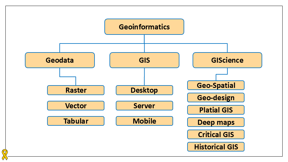
Both GIScience and GIS fall under the broader domain of Geoinformatics, which serves as an umbrella term encompassing all aspects of spatial data science, including both theoretical and practical dimensions. Geoinformatics integrates computer science, data science, remote sensing, cartography, and GIS to develop innovative methods for spatial data processing and analysis. It also includes the management and structuring of geodata, which consists of spatial datasets representing geographic features and phenomena