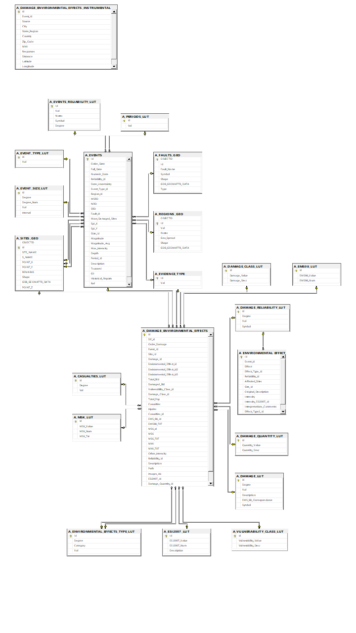

SQL Server database and AGOL webmap designed to store, manage, and analyze comprehensive information about historical earthquakes, their associated damage, and environmental effects. Its structure is optimized for efficient querying, scalability, and integration with advanced analytical tools. Currently, the database is being designed and structures. It uses a relational schema to organize data into well-defined tables and views enabling seamless data retrieval and management. The key tables in the schema include:
Earthquakes: stores detailed information about individual earthquake events, including attributes such as the event ID, date, time, epicenter coordinates (latitude, longitude), magnitude, depth, and region.
Damage: tracks the damage caused by each earthquake, linking damage records to specific earthquake events via a foreign key (event ID). It includes fields for damage categories (e.g., structural, infrastructural), monetary estimates, casualty counts, and affected population statistics.
Environmental Effects: captures the broader environmental impact of earthquakes, including triggered phenomena such as landslides, tsunamis, ground liquefaction, and environmental degradation. Each record links to an earthquake event and includes details like effect type, severity level, and geographical extent.
Sources: documents the sources of earthquake data, including scientific publications, government databases, historical archives, eyewitness accounts, archaeological remains and paleoseismic findings. It provides fields for source type, description, and reference details to ensure traceability and credibility.
Regions: defines geographic regions affected by earthquakes, storing region names, boundaries, and population data. It helps in analyzing the regional impact of earthquakes.
Faults: stores information about geological faults associated with earthquake events. It includes fault IDs, fault names, geographic locations, lengths, types, and movement characteristics. Fault records are linked to relevant earthquake events for detailed fault analysis.
The schema bellow employs primary and foreign key relationships to ensure data integrity and supports indexing for fast retrieval. It is designed to integrate with geospatial tools and analytics platforms, enabling advanced spatial queries and visualizations of earthquake patterns, damage distribution, and environmental impacts.